Landscape architecture is a diverse practice in which designers evolve place at a variety of scales. Throughout history, this practice has included the articulation of urban places through planning, policy, and design. Medellin, Colombia presents a compelling case study in how powerful this transformation can be. Through the lens of social urbanism, Medellin has rapidly improved conditions in both informal and formal communities that suffered an increase in violence during the height of the cocaine trade in the 1970’s.
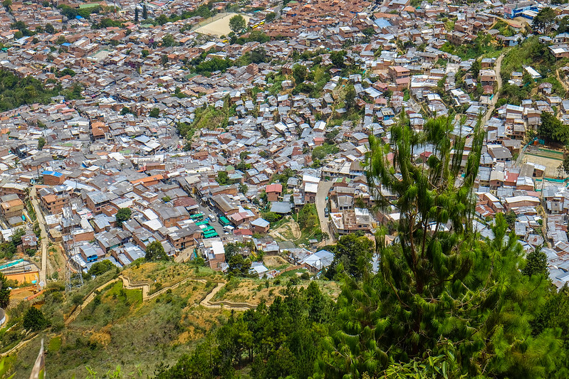
When applied in Medellin, social urbanism is a tool through which designers and planners seek to create social change at multiple scales within the city. Antioquia Governor and past Medellin Mayor Luis Perez has been a champion of this concept. In the 1980’s, Medellin became known as the cocaine capital of the world, which led to urban decay as the city dealt with a spike in violent crime. This violence was felt most dramatically in Medellin’s informal and low-income communities along the edge of the city. Informal communities are squatter developments in which individuals or families create their own housing on land they do not own. Often, these developments occur along the edge of Medellin due to the topography which had made development unsafe due to an increased landside risk. By 1993, the Medellin Cartel had been dismantled and Medellin was slowly recovering from once being the most murderous city in the world with a murder rate of 381 per 100,000 inhabitants.
As an engineer, Mayor Perez understood the importance of infrastructure in creating social change. Under his leadership, Medellin developed high-profile transportation projects including Metro, the first high-speed rail project in Colombia. Perez also championed a variety of innovative infrastructure projects, including Metrocable, which provides access to the economic opportunities within downtown Medellin. After being elected Governor of the Department of Antioquia, one of the thirty-two departments, or states, within Colombia, Sergio Fajardo was elected Mayor and continues to evolve Perez’s concepts. Fajardo developed a new planning agency, EDU, or Empress de Desarrollo Urbano. EDU, a quasi public agency, oversees the strategy for social equity through planning and design working collaboratively with other public and private organizations.
EDU breaks down projects into two types. The first category includes large-scale urban projects that create critical nodes within low-income and informal communities. Internally, the government refers to these projects as “structuring axis” because after completion, they site the articulation of social urbanism through the development of smaller infrastructure projects directly adjacent to them, creating a corridor. These projects include the Metrocable stations and the city’s famous library projects. The first such projects included the development of Library Espana and the first Metrocable line to Santo Domingo. The second project type includes smaller scale urban projects that are designed at creating better integration within the community. These projects are focused on site specific interventions and have included the development of community gardens, neighborhood centers, smaller scale community parks, and public art. One example of this type of project is the community gardens of Moravia. Moravia is a landfill site that sits on the Medellin River inhabited by Medellin’s poorest residents. As parts of the landfill have filled up and been capped, the city has developed community gardens. Socially, this shows a deep understanding of the residents of Moravia who often immigrate from the Antioquia countryside and have farming backgrounds. This project also created ecological services that help to remediate the Medellin River, which is one of the dirtiest urban rivers in the world.
With this complex social history in mind, Boston Architectural College students engaged in a ten-day immersive experience in Medellin, followed by a fall studio with the goal of considering how social urbanism can be utilized as a tool for Pajarito, a community in flux along the Iguana River. Located on the north-west side of Medellin, topography, risk of landslides, and the unhealthy nature of the Iguana River are just a few of the physical charecteristics of the site that required thoughtful consideration. Socially, the mix of informal and formal government housing, a diversity of residents, and the rapid densification of this neighborhood were equally important in considering potential interventions. The complexity of this site also necessitated consideration at a variety of scales, which was achieved through regional and local analysis, Pajarito master planning, and site design. The following pages present my goal of connecting Pajarito locally and regionally through the creation of a robust transportation network while building on recent projects to develop localized nodes that incorporate transit, housing, and social opportunity.
You can view my final studio project on Issuu